Sunday, December 14, 2008

Map Rambles - a gift

Map Rambles were created in March 2007 by Andrew Stuck and Tim Waterman, who had an inspiration prompted by visits to the London: A Life in Maps exhibition at the British Library.


Map Rambles are self-guided walks that incorporate themes inspired by events and exhibitions, in which participants explore areas and come together to discuss and map their experiences.

The concept of a Map Ramble is really simple - bring people together to ramble through a neighbourhood in small groups, exploring and interpreting the environment around them. Issue them a sketch book and pencil, and encourage them to take photos and to draw what they find on their ramble. Bring them together after a couple of hours, and offer them the opportunity to draw a collated map of their routes and discoveries.

Map Rambles proved popular, and won acclaim from Time Out, and four such rambles were organised by Andrew and Tim and their partners, Mel and Jason. You can read about those Map Rambles by following the posts to this blog.

Our intention, right from the beginning, was to pilot the Map Ramble concept in 2007 and gift it to the world, so that anyone could use the format to get people together to explore and interpret their surroundings. So it is over to you....

Increasingly however, we are being asked to tell the story behind Map Rambles and to resurrect them once again.

Tuesday, August 21, 2007

Paddington to Portobello

Come join our next Map Ramble on Sunday 16 September - we are planning to explore the neighbourhoods around and between Paddington and Portobello and want to enlist your help in mapping discoveries.

New to Map Rambling? Time Out, London has already awarded our Map Rambles a "highly recommended" and what we offer is a great way to meet people, make friends, to create and share discoveries in London neighbourhoods*. Still uncertain - read Why Map Rambling is unique by clicking on our previous post.

We’ve mapped an itinerary for the Paddington and Portobello Map Ramble to entice you to join us:

11.00am Map ramble start – join fellow Map Ramblers at the Sloe Bar Café, at Paddington rail station (not the tube station), - choose a themed Map guide, collect a sketch book, and set out in small groups, on a Map Ramble around the local streets, to collect your ideas.

Paddington has been undergoing a regeneration with new office and residential accommodation that opens up the canalsides. Within ten minutes to the south of Paddington is Hyde park and the intriguing Arab neighbourhoods centred on Edgeware Road. To the north and west, discover Little Venice - does it really live up to its name? Catch the rythms of the music and the colours of Portobello Road. All within an easy Map Rambling reach.

We are teaming up with Transport for London's Walking Weekend and London Open House's "Architiecture in the Flesh" - why not include a couple of Open House visits as part of your Map Ramble? Try St Mary Magdalene-in-Paddington Parish Church in Rowington Close or the New West End Synagogue in St Petersburgh Place - both just a stone's throw from our lunchtime rendez vous. Check out the links we've provided at the bottom of this post.

1.30pm reconvene for lunch at The Cow, 89 Westbourne Park Road, London W2 5QH, for a chance to share and map your discoveries with fellow Map Ramblers.

Afterwards, contribute your findings to the Map Ramble web at the Map Ramble web log - these might be sketches, photographs or recordings - please note we don’t provide equipment.

Email: Map Rambles to register.

We recommend you use Journey Planner to find your best route to Paddington rail station.

Just click through here to find out more about the London Walking Weekend or London Open House.

* We went on a reconnaisance Map Ramble in Belgium last weekend with mixed results, and we are planning other Map Rambles further afield, so keep checking back at the blog!

Saturday, July 21, 2007

Rotherhithe Rendez Vous


Parkside Cafe
Originally uploaded by maprambles
Map Rambles gather at the Parkside Cafe in Southwark Park at the start.
Map Ramblers rendez vous-ed at the Parkside Cafe in Southwark Park on Saturday 14 July to ramble around Rotherhithe and rendez vous at the Brunel Museum, just behind Rotherhithe tube station.


Dockyard heritage
Originally uploaded by maprambles
Striking colours on this redundant bridge - just beyond Surrey Quays.


Greenland Dock looking NE
Originally uploaded by maprambles
Looking towards Canary Wharf - some birds have chosen to nest on the artificial islands, others just choose anywhere.


We were lucky as the rain held off and we were able to take full advantage of the amazing out door iron work sculpture of a boat's hull that has been brilliantly designed as a table for twenty.

This ironwork sculpture of a ship's hull has been ingeniously designed as a table that sits twenty - the perfect place Map Ramblers to get mapping.


Map Ramblers conscientiously illustrating their map.Check out the detail of this mural! One Map Rambler spotted 19 species of birds while rambling in Rotherhithe.


Ramblers mapping
Originally uploaded by maprambles
Just putting the finishing touches to their maps.


Please join us for our next Map Ramble that will probably take place not far form Paddington on Sunday 16 September 2007 - London's Walking Day. Join us on a voyage of discovery.

Wednesday, June 13, 2007

The French Connection - Map Ramble

Please join us for a Map Ramble that begins at the Parkside Café & Bar, Southwark Park, by Gomm Road, London SE16 2UA on Saturday 14 July 2007. Join us on a voyage of discovery.


Map Rambles are self-guided walks that incorporate themes inspired by events and exhibitions, in which participants explore areas and come together to discuss and map their experiences.

We’ve mapped an itinerary for the Map Ramble to entice you to join us:

11.00am Map ramble start – join fellow Map Ramblers at the Parkside Café & Bar, Southwark Park, at the end of Gomm Road - choose a themed Map guide, collect a sketch book, and set out in small groups, on a Map Ramble around the local streets, to collect your ideas.

Explore Southwark Park (with its new art gallery), step into the streets of old Rotherhithe with their shipping and seafaring heritage, where people have lived and worked cheek by jowl for centuries. Catch glimpses of river traffic along narrow streets. Bermondsey to the west, and Deptford to the south, the neighbourhoods here are bounded by the river and ooze memories with street names and dock areas that resonate with faraway places.

1.30pm reconvene for a picnic (weather permitting) at the ship’s table at the Brunel Museum, St Mary’s Church Street or at the Angel Inn, Bermondsey Wall East, for a chance to share and map your discoveries with fellow Map Ramblers.

Afterwards, contribute your findings to the Map Ramble web at the Map Ramble web log - these might be sketches, photographs or recordings - please note we don’t provide equipment.

Email: Map Rambles to register.

Parkside Café & Bar is situated in Southwark Park, less than 10 minutes walk from either Canada Water on the Jubilee Line, or Surrey Quays on the East London Line. location map We recommend you use Journey Planner to find your best route.

Tuesday, May 8, 2007

Map Rambling - why it is unique.


Here are some images that tell the story of a Map Ramble - as the old adage says " a picture tells a ...".

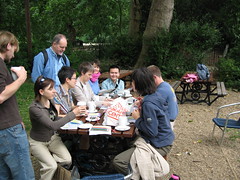
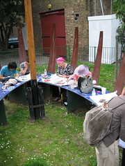
Map Ramblers convene at a place we select - yes, these things are planned - we try to choose a freely accessible venue that provides shelter (should it rain) and a place to buy some refreshments. We also try to choose somewhere that may contribute ideas or inspiration for the Map Ramble - for our last two Map Rambles we chose the First floor cafe at the British Library (NW1 2DB) and the restaurant at the Geffrye Museum (E2 8EA) - pictured above are some early bird Map Ramblers at the Geffrye Museum.


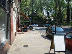
Occasionally we have to remind participants to stop talking and get up and Map Ramble - as you can tell the early birds were well bedded in at the Geffrye Museum. Perhaps they are discussing which themes they might incorporate in their Map Ramble - we usually draw up a list of themes, but also allow participants to choose their own. Themes are only for prompting thought and discussion. We try to set off from 11.00am and Map Ramble for a couple of hours or so - here is a picture of some Map Ramblers setting off from the Geffrye Museum - Map Rambles are self-guided. There is no leader taking participants on a prescribed route, instead it is for the Map Ramblers as groups (or alone if Map Rambling alone) to decide where to go.

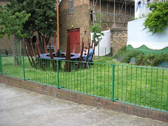
After a couple of hours Map Rambling (either alone or in groups), participants meet at a pre-determined place. Our last Map Ramble began and ended at the restaurant at the Geffrye Museum.

What makes Map Rambling unique?


When Map Ramblers come together after they have been rambling, they are invited to share and map their discoveries. Simple as that - or rather look at these other photographs to get a picture of what takes place.

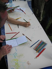
Map Ramblers are each given a sketch book and pencil to help them record what they observe on their Map Ramble. Many of them take photographs, and some take audio and video recordings, others collect 'flotsam and jetsam" as souvenirs from their ramble. Together they are encouraged to Map their routes and record their discoveries on a large piece of paper (we provide the paper!).

Here's a picture of two proud Map Ramblers with their shared hand drawn map - they don't appear to have exerted themselves much - can we be sure that they actually went on a ramble?

Some Map Ramblers have told us that they enjoy drawing their encounters, ideas and observations - it is all in the detail. Others like the opportunity of discussing how their discoveries should be best illustrated or mapped. The creation of the maps of shared discoveries is a catalyst for discussion and general enjoyment.

Every Map Rambler receives their own sketch book and pencil - you should see the state of some of those that have been used on previous Map Rambles (or as useful notebooks for the shopping list etc.). We come equipped with lots of paper on which to draw maps, pencils, coloured crayons and pens, and sheets of tracing with which to create overlays.

Come along and join us, just by sending an email to Map Rambles to register.

We are novices at publishing the maps. We are looking at ways to scan the maps and publish them on this blog or other social networking websites, and we are also interested in creating interactive maps, so if you have an interest and a skill you are prepared to share then we would love to hear from you.

Happy Map Rambling

Monday, May 7, 2007

Map Rambling - round trip from the Geffrye Museum to Brick lane


From within the Eel & Pie shop
Originally uploaded by maprambles.
On Bethnal Green Road on the way to Brick Lane, you can stop by S & R Kelly's Eel & Pie Shop. Served with thick parsley sauce - thanks Viv.


Footbridge to where?
Originally uploaded by maprambles.
Just off Cheshire Street you can take this short cut to where?


Vacuum cleaner graveyard
Originally uploaded by maprambles.
Not the most attractive alley in the East End.


Spitalfields City Farm
Originally uploaded by maprambles.
Welcome - it's free,
We run on donations you see
The animals live
on the money you give
So please give generously

The City Farm didn't appear to be open when we Map Rambled by - shame.


Road Closed
Originally uploaded by maprambles.
Not a very inviting route as it is - let's hope they can make it better.


Gutter press?
Originally uploaded by maprambles.
Just cannot take it unless I take it lying down.


Armold Circus - street cafe
Originally uploaded by maprambles.
Chatting at the pavement cafe.

Map Ramble from the Geffrye Museum, Shoreditch, London

This elegantly tiled entrance way was not the only thing that caught our attention, so did the padlock and chains that denied entrance to Hoxton Community Garden - what's going on?


Street side hoardings make excellent canvases for graffiti artists.


Look up as well as down whenever you go Map Rambling!